
The trails in the Irvington Woods provide for everything from leisurely strolls to strenuous bicycle rides. Click a tab to the right of the Trails Map below to reveal information and a downloadable map of the selected trail.
The numbers on the map correspond to numbered trail markers within the woods. Village emergency services uses the number system on the map to identify locations. On the right-hand side of the page, there is a complete list of those locations.
There are some hike suggestions, beginning from the trailheads behind the O’Hara Nature Center and the Parking lot at Cyrus Field Road on the Suggested Hikes page:


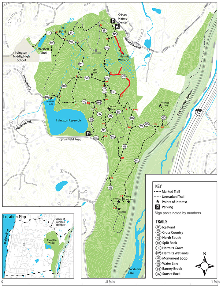


Ice Pond
Rating: easy
Distance: .5 mi
Time: 1/2 hour
Surface: compact dirt
Modes: hiking, biking-trails
Description: Starting from the parking lot on Mountain Road, the North-South Trail (NS) quickly intersects with the Ice Pond Trail (IP). IP leads to a small man made pond where ice was harvested on the former Stearns Estate, continues west to Marshall’s Pond, and ends at the
playing fields behind the High School.
DOWNLOAD THIS TRAIL MAP
Cross Country
Rating: easy
Distance: .5mi
Time: 1/2 hour
Surface: compact dirt
Modes: hiking, biking-trails
Description:
DOWNLOAD THIS TRAIL MAP
Distance: .5mi
Time: 1/2 hour
Surface: compact dirt
Modes: hiking, biking-trails
Description:
DOWNLOAD THIS TRAIL MAP
North South
Rating: easy
Distance: .55mi
Time:
Surface: compact dirt
Modes: hiking, biking-trails
Description:
DOWNLOAD THIS TRAIL MAP
Distance: .55mi
Time:
Surface: compact dirt
Modes: hiking, biking-trails
Description:
DOWNLOAD THIS TRAIL MAP
Split Rock
Rating: easy
Distance: .13 mi
Time: 10 mins
Surface: compact dirt
Modes: hiking, biking-trails
Description:
DOWNLOAD THIS TRAIL MAP
Distance: .13 mi
Time: 10 mins
Surface: compact dirt
Modes: hiking, biking-trails
Description:
DOWNLOAD THIS TRAIL MAP
Hermit's Grave
Rating: easy
Distance: 1 mi
Time: 1 hour
Surface: compact dirt
Modes: hiking, biking-trails
Description:
DOWNLOAD THIS TRAIL MAP
Distance: 1 mi
Time: 1 hour
Surface: compact dirt
Modes: hiking, biking-trails
Description:
DOWNLOAD THIS TRAIL MAP
Hermit's Wetland
Rating: easy
Distance: .25 mi
Time: 15 mins
Surface: compact dirt
Modes: hiking, biking-trails
Description:
DOWNLOAD THIS TRAIL MAP
Distance: .25 mi
Time: 15 mins
Surface: compact dirt
Modes: hiking, biking-trails
Description:
DOWNLOAD THIS TRAIL MAP
Monument Loop
Rating: easy
Distance: 1.25 mi
Time: 1 1/4 hour
Surface: compact dirt
Modes: hiking, biking-trails
Description:
DOWNLOAD THIS TRAIL MAP
Distance: 1.25 mi
Time: 1 1/4 hour
Surface: compact dirt
Modes: hiking, biking-trails
Description:
DOWNLOAD THIS TRAIL MAP
Water Line
Rating: easy
Distance: .36 mi
Time: 20 mins.
Surface: compact dirt
Modes: hiking, biking-trails
Description:
DOWNLOAD THIS TRAIL MAP
Distance: .36 mi
Time: 20 mins.
Surface: compact dirt
Modes: hiking, biking-trails
Description:
DOWNLOAD THIS TRAIL MAP
Barney Brook
Rating: easy
Distance: .15 mi
Time: 10 mins.
Surface: compact dirt
Modes: hiking, biking-trails
Description:
DOWNLOAD THIS TRAIL MAP
Distance: .15 mi
Time: 10 mins.
Surface: compact dirt
Modes: hiking, biking-trails
Description:
DOWNLOAD THIS TRAIL MAP
Sunset Rock
Rating: easy
Distance: .5 mi
Time: 1/2 hour
Surface: compact dirt
Modes: hiking, biking-trails
Description:
DOWNLOAD THIS TRAIL MAP
Distance: .5 mi
Time: 1/2 hour
Surface: compact dirt
Modes: hiking, biking-trails
Description:
DOWNLOAD THIS TRAIL MAP